2/29/2024 Pakistan Exploratory Skiing
By Matt Randall, Photos by Chris Kussmaul and Matt Randall
The Hunza District of Pakistan
If you've ever thought about Pakistan in the context of ski mountaineering, you've most likely thought of the Baltoro region, which lies in the Shigar District in the northern part of Pakistan. This iconic valley boasts access to some of the world's most picturesque and iconic peaks: Trango Tower, K2, and Laila Peak, amongst many others. Because of its well-deserved reputation, this region also sees epic levels of tourists, who flock to the area to be in the presence of these impressive peaks.
While not as well known, the Hunza District lies approximately 50 miles northwest of the Shigar District. While none of the local peaks reach the mythical 8,000-meter mark, this region of the Karakoram nonetheless plays host to impressive peaks of its own, such as Rakaposhi, Distaghil Sar, and others. This region also sees far less tourism than its better-known cousin to the south, which is largely why Chris Kussmaul, Bill Copeland, and I set our sights on this region to go exploring.
Into the Karakoram
Perhaps foreshadowing the trip, my experience getting into the Karakoram was an adventure in itself. To start, our trip was delayed by four days as I sorted through issues with my travel visa. Once my visa was cleared, I hopped on the next flight to Pakistan and landed in Islamabad at 2 a.m. Not wanting to delay the trip any further, I immediately began the 14-hour drive along the infamous Karakoram Highway (KKH) to meet up with Chris and Bill, who were staying in the capital of the Hunza District, Karimabad.
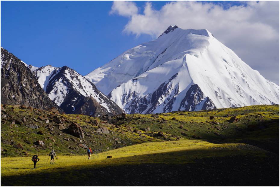
The following day, we drove further along the KKH on the "engaging" road to Shimshal, where we were welcomed with lush green fields and stunning views. It was here in Shimshal that our logistics provider, Ghafoor, organized porters and pack animals to help us with our four-day trek to base camp.
On the way to base camp, we hiked up and over Boesam Pass (16,400’) to the north of Shimshal, passing picturesque ski lines left and right. Unfortunately, we had a long way to go, so we made mental notes for future trips to the region and kept plodding forward.
One night during the trek to base camp, a Shimshali herder slaughtered a goat and treated us to a local meal. While the meal was excellent, Chris unfortunately got food poisoning, which almost required emergency intervention. Thankfully, Chris was able to pull through, and the following day we followed the Ghujerab River upstream, where we set up basecamp at ~14,600’. The only sign of life at base camp was a herd of yaks, which were the only company we would have for a few weeks.
North Ghidims Glacier High Camp
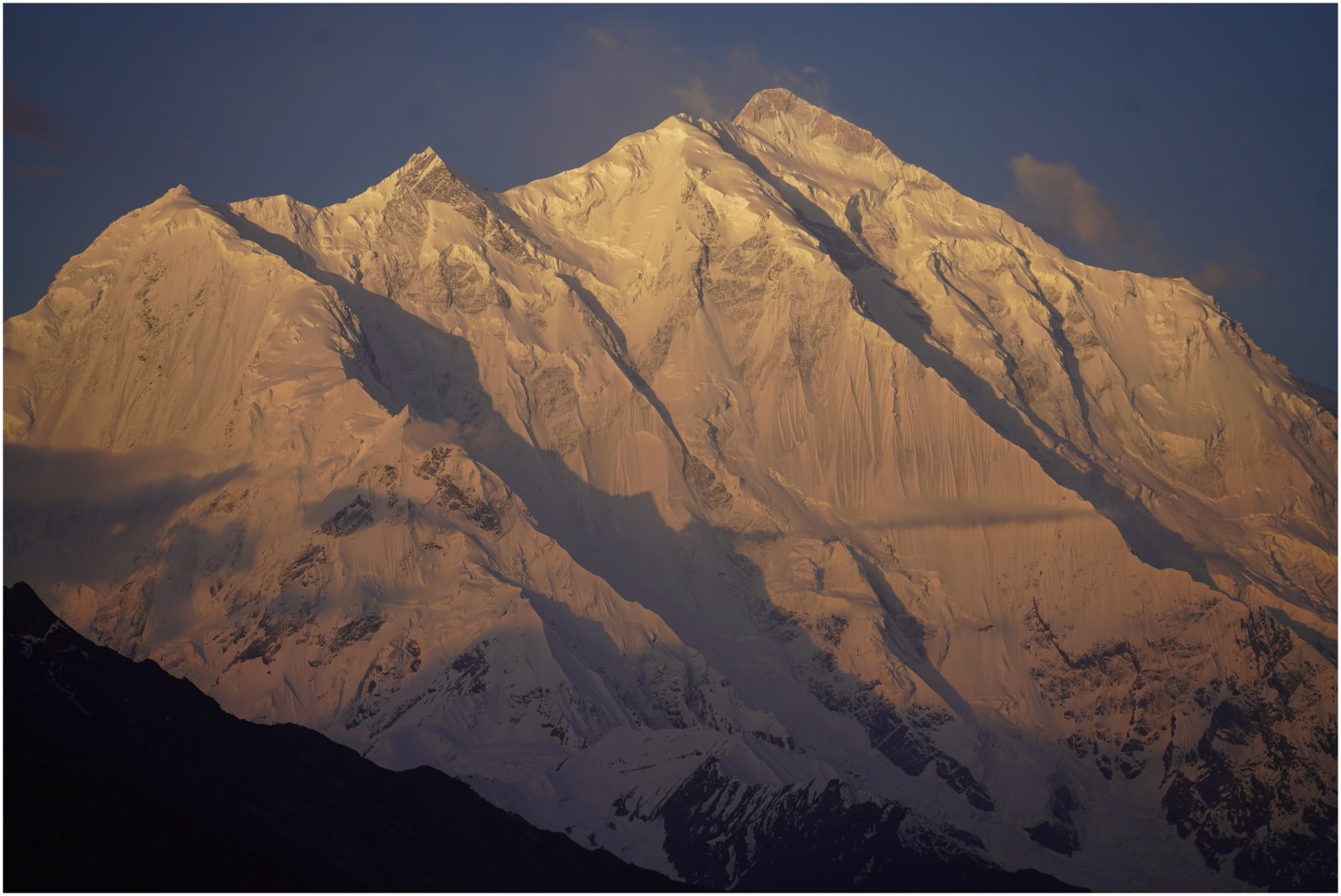
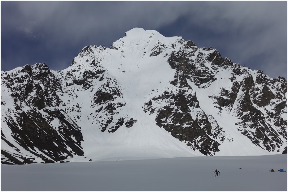
After a day of rest at base camp, we set up our “high camp” at the confluence of the left and right ice flows of the North Ghidims Glacier. Standing over us to the northeast was a brilliant view of the crown jewel of the area: Yawash Sar II. This camp would serve as our launching-off point to climb and ski peaks in the area.
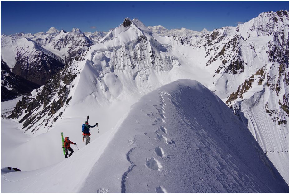
Yawash Sar Middle (18,982’), South Face
I had seen Yawash Sar Middle in the American Alpine Journal while doing the obligatory pre-trip research and learned that it offers a consistent 35-45 degree angle and only a few small rock bands to negotiate. These two factors made it a very appetizing and an approachable first ski objective for the area.
On the ascent, we climbed a mellow gully to the lookers right side of the peak to gain the ridge, which turned into a knife-edge ridge on the final 100' to the summit. On the summit, we had one foot in Pakistan and one in China (whoops!).
For the descent, we walked back along the thin and exposed ridge to put our skis on (splitboard for Bill). The initial turns off of the summit were tentative, as the snow was still quite firm. We didn’t wait for the firm south-facing snow to soften because the supportive ski crust might turn into a breakable crust, making for a much more engaging descent.
Luckily, this supportive crust was quite "edgeable" and we enjoyed smooth, firm turns for the first half until a little route finding began. We zigged and zagged between a few small rock bands and eventually got to the bottom of the face, which had accumulated a good amount of avalanche debris from higher up. We picked our way to a small tongue of snow that eventually spit us out onto the wide-open slopes directly above the glacier, where we were able to enjoy cruising back to camp.
This was the perfect first objective!
Ghidims Sar (19,731’), Northwest Ridge and “Cache Peak” (~19,300’), West Face
After skiing Yawash Sar Middle, we returned to base camp and waited out a week-long storm. After the storm abated, we headed back up and gave the slopes another day to settle to reduce the avalanche risk.
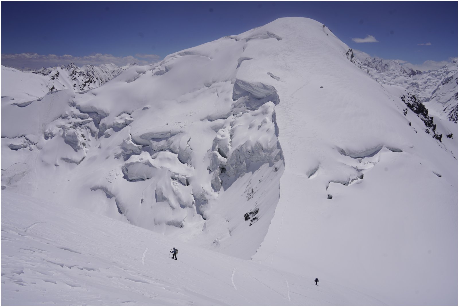
An early (and very cold!) start the next morning had us heading towards the namesake peak of the area, Ghidims Sar. We planned to climb and ski Ghidims Sar and then summit a nearby ~19,300’ peak we had dubbed “Cache Peak” due to its proximity to our gear cache.
We arrived at the base of the slope that would give us access to the slightly corniced northwest ridge of Ghidims Sar. We booted up towards a break in the looming cornice and I took the lead, burrowing through the broken portion of the cornice. The effort warmed me substantially until I plopped onto the other side of the ridge; shaded, windy, and cold. I set up a body belay and belayed both Chris and Bill up.
With everyone on the ridge and cold, we wasted no time and headed up the northwest ridge. Soon we were on the summit, where we all ducked into the sun and out of the wind as we thawed our hands and feet. Chris would eventually realize that he had sustained peripheral frostbite to his toes, which would plague him for the rest of the trip.
For Chris and I, the ski down the northwest ridge was "character building," as it was mostly breakable crust. Bill on the other hand, on his splitboard, simply plowed through the crust with ease, which made Chris and I quite envious. At the bottom of the ridge, we transitioned for a short climb up the southeast ridge of “Cache Peak” and were soon on top. Even though the linkup was less than 4,500’ of gain, at 19,000’, we were feeling it!
From the summit, the west face steeply rolled over, not allowing us to see what was below. We opted to follow the ridge down a few hundred feet until we gained clear sight and access to the west face, where we skied more breakable crust down the first half of the face, though, the snow eventually turned into smooth corn as we cruised to the toe of the glacier.
A quick nap in some rocks and a short skin brought us back to our high camp, exhausted and stoked.
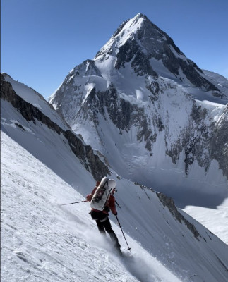
Yawash Sar II, West Face
At this point in the trip, Chris and I had two good weather days remaining before needing to pack up and head to the Baltoro to meet fellow Wasatch skier, Jess Shade, for the 2nd month of the trip. With this time constraint in mind, we set our eyes on the crown jewel of the area: Yawash Sar II.
Yawash Sar II was the main reason we came to the Ghidims Valley. I had been looking through the American Alpine Journal during the winter of 2021 and ran across an article with a picture of its picturesque and stunning west face.
Our first attempt ended with us bailing about halfway up the west face. A storm had come in the night before, and the new snow still wasn't very well settled. To make matters worse, the temperature was steadily rising and the sun started to peak out. We quickly turned back and headed to the relative safety of our camp, where we watched the west face shed the rest of the day. Needless to say, we were very happy to be in camp and not on the face.
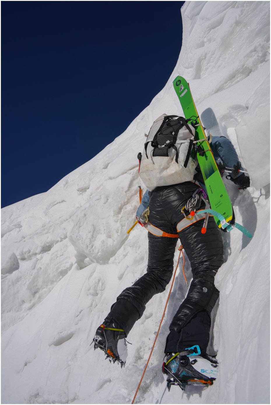
The next morning, we got an earlier start and set off. Bill had developed a nasty cough the previous night due to a cold and unfortunately had to turn back a short way in. Chris and I worked up the lower face which averages 40-45 degrees. It was a completely different face than the day before. What had been smooth snow the day prior turned into massive icy runnels with strips of snow in between what hadn’t shed. Arriving at the base of the upper face, Chris and I were welcomed to a consistent pitch of 50-degree snow, which made for exciting booting!
We front-pointed up the first few hundred feet and then began to traverse out onto the final face to the summit. About 300 feet from the summit, we encountered a thick slab of firm snow sitting on top of a foot of facets, which in turn was sitting on top of alpine ice. We stopped and had a heart-to-heart.
After a brief conversation about the tenuous conditions we were in, Chris and I quickly downclimbed to the base of the upper face to put on our skis.
With skis on our feet, we slowly made our way down, linking the snow strips that existed between icy runnels. Bill was waiting in camp with hot drinks which we enjoyed before breaking down camp and heading down.
Afterword
Overall, we only had 5 days of good weather while in Ghidims Valley. While we battled bouts of food poisoning, sickness, and over-zealous customs officials, I feel fortunate to have had even this small amount of time in this rugged place. This portion of Pakistan is stunning, remote, and all that we could have asked for. We look forward to returning to this place in the future.
Comments